


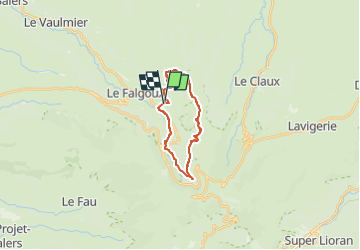
Franconeche- Luchard- chemin des Italiens

Jean Yves Erard
User

Length
17.3 km

Max alt
1554 m

Uphill gradient
695 m
Km-Effort
27 km

Min alt
936 m

Downhill gradient
704 m
Boucle
Yes
Creation date :
2024-07-18 14:01:31.861
Updated on :
2024-07-18 14:01:34.038
6h02
Difficulty : Very difficult

FREE GPS app for hiking
 SityTrail
IGN / Geographical institutes
SityTrail Plus
The world is yours!
About
Trail Walking of 17.3 km to be discovered at Auvergne-Rhône-Alpes, Cantal, Le Falgoux. This trail is proposed by Jean Yves Erard.
Description
départ de la Franconèche, montée au Luchard ( 500 m de dénivelé), plateau de landes magnifique, un peu de Gr400 et retour par le chemin des Italiens
Positioning
Country:
France
Region :
Auvergne-Rhône-Alpes
Department/Province :
Cantal
Municipality :
Le Falgoux
Location:
Unknown
Start:(Dec)
Start:(UTM)
471924 ; 4999608 (31T) N.
Comments